Sri Lanka Holidays
Facebook  Twitter  Google Plus  LinkedIn    My status 

About Us   |   Contact Us   |   Sitemap 

Pick Your Tour

7 Nights Tour

10 Nights Tour

11 Nights Tour

14 Nights Tour

15 Nights Tour

Sri Lanka, the Land of Delights 

Sri Lanka Holidays

Home |  Nature/Adventure |  Ancient Glory |  Rich Package |  Sri Lanka Holidays |  Total Holiday Experience |  Travel Guide |  Lanka History |  Hotel Guide

Must Visit Locations

Waterworld: Ancient Sinhalese Irrigation and Conservation of water

Sri Lanka is a classic example of the "hydraulic civilization" which had developed in the ancient period. With the immigration of Aryans from Eastern India to Lanka in 543 BC, cultivation of rice developed into a grand scale in the island. As the new essentially agricultural Aryan civilization flourished, increasingly ambitious projects of irrigation were launched at a pace with a view to harness the monsoon rains. It can be safely deduced that the first great reservoirs ever in the world were built in Sri Lanka. since the great lakes of Egypt, being merely natural hollows into which streams were turned do not fall into the category of man-made rainwater reservoirs as those of Lanka.

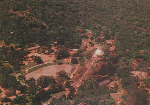
The rainwater reservoirs developed in the ancient kingdom of Anuradhapura (437 BC-845 AD) & Polonnaruwa (846 AD-1302 AD), Dry Zone of central lowlands resulted in two season of farming while the Wet Zone remained sparsely populated and covered by thick forests. Today around 12,000 ancient small dams & 320 ancient large dams together with thousands of man-made lakes dot the lowlands, with over 10,000 reservoirs in the Northern Province alone. Today Ancient Sinhalese irrigation supplemented by Modern Irrigation Projects continue to provide the lifeline: self sufficiency in rice, the staple food of the Sri Lankans.

The vast reservoirs depict the rich cultural heritage of the unbroken recorded civilization of the Sinhalese. Furthermore, in the context of wetlands, it must be noted that non existence of natural lakes in the tropical island of Sri Lanka was compensated by the man-made lakes. The major (ancient & modern) irrigation reservoirs (each more than 200 ha) cover an area of 87854 ha, while the seasonal/minor (ancient) irrigation tanks (each less than 200 ha) account for 52250 ha.

My Sri Lanka Holidays Tour Packages

My Sri Lanka Holidays tour packages involving the Cultural Triangle afford you all, the exhilarating opportunity of enjoying the great spectacle of the hundreds of vast ancient restored irrigation reservoirs and thousands of village reservoirs that sprawl all over the great north central plains: 7 night tour, 10 night tour, 11 night tour, 14 night tour and 15 night tour.

The touristic concept of Sri Lanka Holidays Cultural triangle studded with cultural attractions (i.e. colossal Buddhist stapes and Buddhist temples) is geographically set within the north central plains. Sri Lanka Holidays Cultural triangle encompass the UNESCO World Heritage Sites of Golden Dambulla Rock Cave Temple, Sigiriya Lion Rock Citadel and the ancient Royal Kingdoms of Anuradhapura and Polonnaruwa. Within and around these tourist attractions are the lifeline to the nation: the glorious rehabilitated ancient irrigation schemes based on the concept of conservation of water collected during the two monsoon seasons.

Of these restored ancient irrigation schemes the inland sea-like Parakrama Samudra, Minneriya reservoir, Kaudulla reservoir and Giritale reservoirs (at Polonnaruwa), Nuwara weva reservoir, Tissa weva reservoir and Basawakkulama Wewa reservoir (at Anuradhapura) reveal the glorious 2550 year old unbroken civilization of Sri Lanka. Moreover, adjoining or encompassing the great reservoirs at Polonnaruwa is a cluster of National parks, home to large herds of wild elephants.

This is not to say that the cultural attractions, wildlife parks and vast irrigation reservoirs aren't seen in the other zones of Sri Lanka. Whole of Sri Lanka is a movie set. Should you love beaches, Sri Lanka Holidays beaches in southern coast such as Tangalle take you all closer to Tissamaharama, home to vast irrigation reservoirs of Tissa Wewa (This shouldn't be confused with Tissa Wewa at Anuradhapura), Debera weva as well as the renovated ancient stupas Tissa Maha Dagoba, Sandagiri Dagoba, Yatala Dagoba and Menik Dagoba. Furthermore, Tissamaharama is the gateway to Ruhuna Yala National Park home to elephant, leopard, deer etc and birdlife. What else would you like? Soft adventure sports? Let's go to the Central Highlands. Water sports? Let's go to the southwestern beach of Bentota. Whales? Lets' go the southern beach of Mirissa. Professional surfing? Let's go to Arugambay of Eastern coast


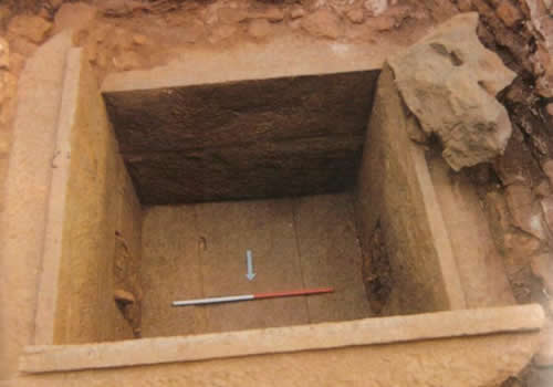
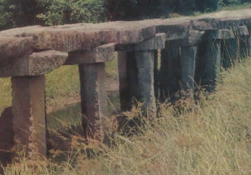
"It is possible, that in no other part of the world are there to be found within the same space the remains of so many works of irrigation which are, at the same time of such great antiquity, and of such vast magnitude, as in Ceylon. Probably no other country can exhibit works so numerous, and at the same time so ancient and extensive, within the same limited area, as this island"
John Baily, Assistant government Agent of Badulla in a report to the Governor of British Ceylon (now Sri Lanka) in the year 1855.

"The stupendous ruins of the reservoirs are the proudest monuments which remain of the former greatness of the country... Excepting the exaggerated dimensions of Lake Moeris in Central Egypt and the mysterious 'basin of Al Aram", the bursting of whose embankment devastated the Arabian city of Mareb, no similar constructions formed by any race, whether ancient or modern, exceed in colossal magnitude the stupendous tanks in Ceylon. The reservoir of Kohrud at Ispahan, the artificial lake of Ajmeer, or the tank of Hyder in Mysore, can no more be compared in extent or grandeur with Kalawewa or Padivil-colam (Padawiya) than the conduits of Hazekiah, the kanats of the Persians, or the subterranean water-courses of Peru can vie with the Ellahara canal, which probably connected the lake of Minneri and the "Sea of Parakrama" with the Anban-anaga river."
Above was narrated by Sir Emerson Tennent (1843-1850) a Colonial Secretary before the extensive investigation, survey and restoration of "Sea Of Parakrama" and "Ellahara canal".

The first rainwater reservoir

The first modest works of hydraulic engineering dates back to earliest days of the Sinhalese civilization of the Island.

Channeling water to the irrigation reservoirs
The conservation of water was done by way of constructing massive causeways and anicuts across the larger rivers and turning the water into excavated channel which conveyed it sometimes many miles, over apparently flat country and impounded the water eventually in large reservoirs of chain of reservoirs. The reservoirs were built in the cascade system at slightly varying elevations so that there often was a series of reservoirs to take the overflow from the one above it. The exit of water was regulated by means of sluices to the rice fields.

300 BC Ancient Bisokotuwa (Queen enclosure) Vs. Modern Sluice gate

The finest example of the ingenuity of the Sinhalese irrigation engineering is the invention of the "Biso-kotuwa" (meaning queen's enclosure in Sinhalese) in 3rd century B.C. Biso-kotuwa is the equivalent of the modern valve-pit, which operates in the regulation of the outward flow of water. It was the invention of biso kotuwa which permitted the Sinhalese to proceed boldly with the construction of vast reservoirs that still rank among the finest and greatest work of its kind in the world. Henry Parker (Irrigation Department, British Ceylon) narrated that by building these "Biso-kotuwas", Sinhalese engineers established a claim to be considered as the inventors of the 'valve-pit' more than 2,100 years ago.


The great royal tank builders of ancient Lanka

  • King Abhaya (474-453 BC): first rainwater reservoir of the island was built
  • King Pandukabhaya (437-366 BC): Abhayawewa (Basawakkulama wewa) rainwater reservoir was built in Anuradhapura. It covers an area of 205 acres today.
  • King Devanmpiyatissa (307-267 BC): Tissavapi or Tissa weva rainwater reservoir was built in Anuradhapura.
  • King Dutugamunu or Duttagamini (161-137 BC): Soraborawawa large reservoir was built at Mahiyangana.
  • King Kutakannatissa (44 -22 BC): Balaluvava in the Kalavava basin was built.
  • King Vasaba (65-108 AD): It was during the reign of King Vasaba the first step in the advance from the village tank to major reservoirs. King Vasaba is credited in the Mahavamsa for building eleven reservoirs, the largest with a circumference of three kilometers in addition to the twelve canals. However Alisara or Alahara is the only canal mentioned by name in Mahawamsa, the great chronicle of Sri Lanka. Maha and Kuda Vilachchiys, in Anuradhapura, Manankatiya in Kekirava, Nochchiyapatana in Manampitiya and Akvadunna close to Sri Lanka Holidays transportation hub of Habarana are some of the tanks built by King Vasaba that can be identified today. These reservoirs cannot be called large though they were built on improved technology when compared to the reservoirs built earlier.
  • King Mahasena (276-303 AD): The first giant reservoirs were constructed by King Mahasena. The vast Minneriya tank & fifteen other reservoirs were constructed by the king Mahasena. The first part of the Mahawamsa, i.e. chapter 37 ends with the chronicler praising King Mahasena: "To ensure plentiful supply of food, he made sixteen tanks built: Manihira, Mahagama, Challura, Khanu, Mhamani, Koavita, Dhammarammma, Kumbalaka, Vahana, Rattamala-kanda. Tissavaddhamanaka, Velangavitthika, Mahagallaka, Cira, Mahadaragallaka and Kalapasana are these sixteen tanks. From the Ganga he built the great canal named Pabbanta. Thus he acquired a great deal of merit and demerit. The Mahavamsa, The Great Chronicle of Sri Lanka. While Manihira reservoir is identified as Minneriya reservoir which submerged 4670 acres of land, Tissavaddhamankavapi, called Rantisavava in inscriptions, is correctly identified by the historian H. W. Codrington of British Ceylon with the present Kaudulla tank, which is nearly as large as Minneriya. Alisara canal or Alahara diverts the water of River Amban ganga, the main tributary of River Mahavali ganga at Alahara. The construction of a weir across the river was a major technical feet: its considerable length meant during the reign of King Vasaba (65-108 AD), the Sinhalese had developed a high degree of instrumental accuracy in contouring and leveling, and had achieved success in building permanent stone dams across large rivers. The shares of the revenue from the canal was donated by King Vasaba to a monastery in the Tissavaddamanaka district, the area around the Kaudulla tank, which is about six miles north of Minneriya. It is this same canal that we see two centuries later becoming the feeder canal of the great Minneriya Tank. However, then existent dam at the headworks of the canal hand to be developed so that it could carry much higher volume of water to fill the new great reservoir. The length of the enlarged and extended canal from the dam to the tank was 25 miles. The Alahara-Minneriya-Kaudulla scheme completed during the reign of King Mahasena (276-303 AD) was an epoch-making event in the backdrop of periods of drought and scarcity of food during the reign of King Kunacanaga (195-196 AD) at Anuradhapura, Sangabodhi (252-254 AD) at Anuradhapura and the severe famine and resulting deaths of thousands of Theravada Buddhist bhikkus (Sinhala:priests) in the reign of King Valagambahu or King Vatthagamini (103 BC ) & (89-76 BC) at Anuradhapura. Although King Valagambahu supported Mahayana Abhayagiri bhikkus at the expense of Theravada Mahavihara bhikkus, he saw the necessity of having the oral tradition of Triptiaka (the three books of Theravada Buddhism: Sutra pitaka- sayings of Buddha- approximately 10,000 suthras or discourses; Vinya pitaka: disciplinary rules for monks; Abhidharma pitaka: Analysis of Buddhist philosophical system) and Atthakatha (Sinhala: commentaries) committed to writing. It was carried out by 500 Theravada Buddhist bhikkus (Sinhala: priests) assembled at Aluvihare Rock Temple at Matale, 26km north of Sri Lanka Holidays Kandy. While the Tripitaka was written in Pali, the commentaries to Thripitaka were written in Sinhalese. Sinhala Atthakata was translated to Pali in the 5th-century by the Indian Theravadin Buddhist commentator and scholar Bhadantacariya Buddhaghosa, who authored Visuddhimagga (Pali: Path of Purification), a comprehensive summary and analysis of the Theravada understanding of the Buddha's path to liberation in Sri Lanka.
  • King Dhatusena (461-478 AD): Chulavamsa, the second part of Mahawamsa records that a Mauryan prince by the name of Dhatusena, having left the order of Buddhist Monks rescued the Sinhalese nation and Buddhist faith of Sri Lanka from the marauding Dravidian invaders who wreaked havoc during the period of 434-461 AD. Having crowned the king of Sri Lanka, Dhatusena had the immense Kalavapi or Kala Wewa reservoir built (24km South-East of Dambulla) and had it connected to Tissavapi or Tisa wewa at Anuradhapura by way of a canal called Yoda Ala ( Sinhala: giant canal) or Jaya Ganga 87 km in length with a subtle average gradient of 1 ft per mile. Moreover, Sinhalese historical work Pujavaliya written in the 13th century attributes the construction of Yoda Weva (Sinhala: Giants Tank) at Mannar to King Dhathusana. Yoda weva was fed by a 17 mile long canal which began at a dam built across Malvatu Oya or Aruvi Aru. Such was the dedication to irrigation of Sri Lanka, so colossal was the resources expended to build the reservoirs, when Dhatusana's eldest son Kassapa (builder of Sigiriya) demanded the royal wealth, Kng Dhatusena, at the bank of Kalavap or Kala weva, showing the immense man-made lake said "Here is the whole of my royal treasure". King Dhatusena had no treasure that could be compared to vast Kala weva reservoir.
  • King Moggalana (497-515 AD): Chulavamsa, the second part of Mahawamsa records that King Moggallana dammed up the Kalamba river (i.e. the river flowing past the eastern side of Anuradhapura, now called Malvatu-oya) among the mountains forming thereby the Pattapasanavapi, Dhanavapi and Garitara tanks.
  • King Moggalana 11 (540-560 AD) : Chulavamsa, the second part of Mahawamsa records that King Moggallana dammed the Malvatu Oya river and built three reservoirs. Present Naccaduva, one of his reservoirs located 7 miles south of Anuradhapura, is one. This large reservoir submerged 4,408 acres of land. The supply of water to Naccaduva tank was bolstered by a six miles long canal that branched off from Jayaganga built by King Dhthusena. Chulavamsa also attributes the construction of a reservoir called Dhanavapi to Moggalala 11. Dhanavapi reservoir is identified by illustrious Dr. Senerath Paranavitana (1896 1972) as Padaviya reservoir having a capacity of 84 million cm and covering an area of about 2425 hectares. Today following the restoration Padaviya reservoir is slightly smaller than Kala wewa & Minneriya weva. Thus we see the birth of Nuvara Kalaviya, a name signifying the three great reservoirs of Anuradhapura and Polonnaruwa: Nuwara Weva; Kala weva; Padaviya weva. The provinces were also called Weve Bandi Rajje (Sinhala: kingdom of reservoirs) in view of the reservoirs built in the each and every village.
  • King Aggabodhi 1 (564- 598 AD): Sinhalese historical chronicles Pjuavaliya, Rajavaliya and Rajaratnakaraya record that King Moggallana 11 built Kurundavapi or Hurunda weva reservoir (identifiesd as the reservoir called Tannimurippukulam near the ancient Kurunda Vihara Buddhist temple at Mullativu district and Manimekhala (Minipe) dam on the River Mahavali Ganga, which gave rise to Minipe Canal17 miles in length (extended in the 9th century) and great canal leading out of Minnariya reservoir. King Aggabodhi 11 (598- 608 AD): Chulavamsa, the second part of Mahawamsa records that King Moggallana 11 built Mahindatata reservoir at the foot of Mihintale Hill and a bathing pond named Nagasondi tank (Nagapokuna) at Mihitale. King Aggabodhi 11 is credited in Chulavamsa with the construction of the great reservoirs of Giritatavapi or Giritale located between Sri Lanka Holidays Polonnaruwa and Minneriya and Gangatavapi or Kantale weva (area of 3,263 acres with 52 feet high embankment), one of the largest reservoirs in Sri Lanka. Kantale reservoir is fed by Minneriya reservoir by way of further extension of 29 miles long Alahara canal. The total length of Alahara canal from the Alahara dam on River Ambanganga through the Minneriya tank, to the Kantale tank is 54.5 miles, exact length of the Jaya Ganga (Yoda Ala) canal from Kalaweva reservoir to Tisavava reservoir at Sri Lanka Holidays Anuradhapura. King Aggabodhi 1 and King Aggaboi 11 are henceforth credited with expansion of the Alahara-Minnaeriya-Kaudulla scheme of King Mahasena to include the new tanks, Kantale and Gritale. The expanded longer canal resulted in the requirment of additional supply of water. It was met with the construction of Hottota-amuna dam on the Kalu Ganga, the main tributary of the River Amban Ganga, and a canal 28 miles long which carried the water diverted by the dam and discharged it into Amban Ganga just above the Alahara dam.
  • King Dappula the second (807-812 AD): Panduwewa (Pandu water reservoir) was built by King Dappula the second
  • King Parakrambahu the great (1164-1196 AD) The royal master builder of tanks During the reign of the great king, Lanka became to be known as the Granary of the Orient. King Parakramabahu the great was responsible for construction or the restoration of 165 dams, 3910 canals, 163 major tanks (reservoirs) and 2376 minor tanks, 341 stone sluices all in a reign of 33 years, achieving supreme developments in irrigation and agriculture of the Sinhalese civilization during its 2550 year long unbroken civilization.
     

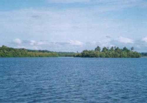
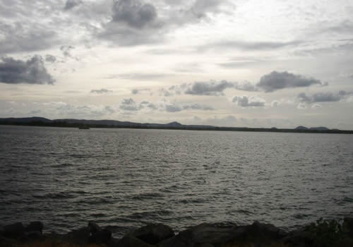
The Sea of Parakrama (Parakrama Samudra)

Network of canals to surrounding area

One of the canals (Yoda Ela, also called Jaya Ganga), the ancient engineers demonstrated their prodigious skill maintaining a steady gradient of less than 20cm per kilometer (1 ft per mile) over distances that eventually stretched to 80 km (50 miles).

The Dams

The dams were built at an oblique angle, exposing the masonry to a lesser degree of violent shocks caused by impact of large floating tree trunks and other debris.

Decline of the ancient Hydraulic civilization of Sri Lanka

Quote A. Dennis N. Fernando (Fellow National Academy of Sciences)

The fall of the ancient hydraulic civilization of Sri Lanka in the 13th century was due to sudden Natural Cataclysmic change of the river course of the Mahaweli Ganga & was not due to foreign invasions as historians would want us to believe. The scientific evidence is clearly seen in the aerial photographs of the old course of the Mahaweli Ganga & its new river courses. The ancient Mahaweli with its ancient chaityas which were beside the old river like a string of pearls now lay stranded beside it. While the present river flows elsewhere with no chaityas beside it which event took place in circa 1220 AD. This sudden geological cataclysm that changed the river course that sustained our ancient hydraulic civilization, led to disease & famine. This resulted in the major part of the population to abandon these areas & move to the Wet & Intermediate Zones where the king also established himself at Dambadeniya, Kurunagala, Gampola, Kotte & Kandy. Unquote. 'Chaityas' is another name for stupas (dagobas)

Further Decline of Ancient irrigation schemes during British Colonialism (1815-1948) in Ceylon

During the early period of British rule the colonial administration was pre-occupied with military & political consolidation, & thereafter, with capitalist enterprise in plantation exploiting the riches of the island supplanted cultivation of rice with cash crops, first coffee & then Tea & Rubber. With no interest taken & no support extended to the farmers on irrigation of paddy fields, the tanks gradually fell into disrepair, turning much of the countryside into malarial swampland. A modern historian calls this a "regrettable but understandable situation, given the fact that the higher bureaucracy itself had been so deeply involved in plantation agriculture"

To give the devil his due credit, we must hasten to add that the Sir Emerson Tennent (1843-1850) a Colonial Secretary, who authored the famous book CEYLON-An Account of the Island (1859), focused attention on the importance of irrigation. The British governor, Sir Henry Ward (1855-1869) deserves to be greatly remembered for his enlightened irrigation policy & his insight into the psychology of the Sinhalese farmer. Ward restored some of the ancient irrigation works, stating that the British administrators before him had "...never devoted a fair proportion of the revenue towards the restoration of old works... & the one thing that comes home to every Sinhalese is the improvement of those means of irrigation which the climate rendered indispensable...

Rehabilitation of ancient rainwater reservoirs

The dire situation of the island resulted in a national independence movement taking root over the issues of land, irrigation & cultivation. Having realized the gravity of the situation, during the second half of the 19th century & first half of the 20th century, the British colonialists launched on a project of restoration of ancient rainwater reservoirs. Restoration of the major Kala Wewa rainwater reservoir with a capacity of nearly 145 million cbm was carried about during 1885 to 1887.

Following the independence from the British in 1948, the rehabilitation of major ancient irrigation works has been accelerated by the national leaders of the independent Ceylon.

Largest ancient rainwater reservoirs

The Sea of Parakrama (2100 ha), Kaudulla (2537 ha), Minneriya (2550 ha), Huruluwewa (2125 ha), Kala Wewa rainwater reservoir (2583 ha), Mahakanadarawa (1457 ha), Nachchaduwa (1785 ha), Padaviya (2357 ha), Rajangana (1600 ha)

Large and medium reservoirs

73 major irrigation reservoirs (ancient) covering an area of 70850 ha
160 Medium scale reservoirs (ancient) covering an area of 17004 ha
10000 minor irrigation reservoirs (ancient) covering an area of 39271 ha
Floodplain lakes covering an area of 4049 ha

Ancient irrigation Vs Modern irrigation

"Many are the instances where the modern engineer has frequently found himself anticipated by an unnamed predecessor" Ceylonese historian R. L Brohier

Gal Oya Scheme

In 1952, modern Gal Oya Scheme testified to the brilliance of the ancient masterminds of irrigation engineering in Lanka: the discovery of remnants dated back to 1500 years of a dam site and two sluices almost exactly at the locations determined for the new reservoir by the engineers at the Gal Oya project. In order to preserve the excavated ruins of the dams & sluice gates, the priceless archeological findings, the government decided to move the new dam site to another location.

Maduru - Oya reservoir

In 1978 when modern engineers cleared the jungle to pave the way for the modern Maduru-Oya reservoir they stumbled on an ancient breached earth dam at the very spot where engineering experts had decided to straddle the river. This dam a little over 23 meters high has been dated to be over 2000 years old & indicates the existence of a vast reservoir before its breach.

Natural Wetlands of Sri Lanka

Inland fresh water wetlands (eg. Rivers, streams, marshes, swamp forests, & Villus)

Sri Lanka has an extensive network of rivers & streams that drain a total of 103 distinct natural river basins running to 4500 km. The river basins originate in Central Highlands & flow through all three peneplains. River Mahaweli is the largest in the island.

The Villu wetlands

Although there are no large natural lakes in Sri Lanka, there are several flood plain lakes called Villu cover a total area of 12500 ha. Handapana & Pendiya Villu (796) is the largest of the entire Mahaweli Villu system.

Fresh water Marshes

A good example of Fresh Water Marshes is Muthurajawela Marsh, which is the largest peat bog in Sri Lanka.

Fresh water Swamp Forest

A good example is the Walauwa Watta Wathurana Swamp forest (12ha) located in the Kalu Ganga River basin.

Salt water wetlands

(eg. Lagoons, estuaries, mangroves, saltpans, sea grass beds & coral reefs)

Estuaries & Mangroves

Typical example of estuaries with mangrove wetlands in Sri Lanka includes the Maduganga estuary & the Bentota estuary.

Lagoons

Around 42 lagoons are found around the coast of the island. Examples are Bundala Lagoon, Mundel Lake & Kalametiya Lagoon.

Coral reefs & Sea grass beds

Extensive coral reef habitats occur in the Gulf of Mannar (north western coast), Trincomalee to Kalmunai (East coast) & several areas including Rumassala & Hikkaduwa in the South & Southwestern coast.

Man made wetlands in the island apart from rainwater reservoirs

Rice Fields

Total area under rice cultivation is about 780,000 ha (12% of the total land area) which are characterized by the presence of a standing water body, which is temporary & seasonal.

Salt pans (Salt lewayas)

Hambantota of southern coast is the salt capital of the island. Salt is produced by channeling seawater into the lewayas (pans). The lewayas with dazzlingly white saltpans surround the town. Once the water is evaporated, the residual salt is scraped up, raked in, collected & sold.


MORE INFORMATION: Modern irrigation Projects of Sri Lanka

Sri Lanka Hotel Guide - Hotel Information, Special Offers, News and Trends and much more

Sri Lanka Travel Guide - Travel Information, Special Offers, News and Trends and much more

Photo Gallery

click on photo to enlarge

Man-Made Reservoir

Minneriya Tank

Sea of Parakrama

Giritale Tank

Bisokotuwa

Irrigation Canals

Irrigation Canals

Hotels in Cultural Triangle  |  Hotels in Central Highlands  |  Beach Hotels  |  Geoffrey Bawa Hotels  |  Eco Hotels & Lodges  |  Tea Bungalows  |  Resorts & Spa's

Ayurvedic Treatments  |  Ceylon Tea  |  Spice Island  |  Island of Gems  |  Travel Guide  |  Sri Lankan History  |  About Us  |  Contact Us

Copyright 2007-2012 - All Rights Reserved by Riolta Lanka Holidays (Pvt) Ltd. Web Site Design by Web Crafts (Pvt.) Ltd.